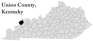
Union county, Kentucky
was formed in 1811 from Henderson County, Kentucky. It is located
in the Western Coal Field region of the state. The elevation in the county
ranges from 320 to 673 feet above sea level. In 1990 the county population
was 16,557 in a land area of 345 square miles, an average of 48.0 people
per square mile. The county seat is Morganfield.
In 1860 parts of Union, Hopkins and Henderson Counties became Webster
County.
Find out more about Union County, Kentucky by visiting the
Political
Graveyard. There you will find out about Politicians who were born
in Union County. And some other interesting facts.
Town's, Communities and Zip Codes In Union County
|
Morganfield
42437
|
Sturgis
42459
|
Uniontown
42461
|
Waverly
42462
|
Sullivan
42460
|
Dekoven
|
|
Grove Center
|
Spring Grove
|
Henshaw
|
Caseyville
|
Sulpher Springs
|
Boxville
|
|
Canney Mound
|
Pride
|
Arnold
|
Blackburn
|
Bordley
|
Chapman
|
|
Cullen
|
Curlew
|
Flournoy
|
Givens
|
Grangertown
|
Grove Center
|
|
Gum Grove
|
Hamner
|
Harding
|
Hazel
|
Herman Valley
|
Hitesville
|
|
Mulfordtown
|
Raleigh
|
Yuba
|
The Rocks
|
Walnut Grove
|
St. Vincent
|
|
Spring Grove
|
Seven Gums
|
Salem
|
Robinsonville
|
|
|
Address's in Union County Kentucky
|
Union County Courthouse, County Clerk's Office
Court House
Morganfield, Kentucky 42437
(502)-389-2264
|
Union County Public Library Dist.
126 South Morgan Street
Morganfield, Kentucky 42437
(502)-389-1696
|
Union County Genealogical Society
Send Correspondence to:
Larry Strehle
5 Congress Drive
Morganfield, Kentucky 42437
Genealogy - Queries to:
Ruth Heffington
130 S. Geiger Street
Morganfield, Ky 42437
|
Union County Residents and Descendant's of
once Residence Home pages
Melissa
Shreve-Owen
**could use an updated link**
|
Jeff Hart
**could use an updated link**
|
Tim & Maria Troutman
**could use an updated link**
|
Ricky & Karena Girten
**could use an updated link**
|
Sandy Butts
**could use an updated link**
|
Allen Tate and Family
|
|
Tim
Brummett
**could use an updated link**
|
Tina
Hall |
|